How Does GPS Triangulation Work? GPS Trilateration Explained
Key Takeaways
-
01GPS uses trilateration, not triangulation, to calculate position
-
02Trilateration calculates location using distances, never angles
-
03Three satellites produce a 2D fix; a fourth adds altitude and removes clock error
-
04GPS signals travel at the speed of light, roughly 186,000 miles per second
-
05Standard GPS delivers approximately 7-meter accuracy 95 percent of the time
How Does GPS Triangulation Work? (Trilateration Explained)
You have probably glanced at a moving blue dot on your phone's map dozens of times this week without once asking how it got there.
I'm Ryan Horban, a GPS tracking expert with more than 15 years of hands-on experience testing vehicle tracking systems for families, fleets, and businesses. One question I get asked constantly is how GPS actually knows where something is. Most people call it "GPS triangulation," but that term is technically wrong. The real process is called trilateration, and once you understand how it works, you will have a much clearer picture of why some GPS trackers update faster and more accurately than others.
In this guide, you'll learn the difference between triangulation and trilateration, how GPS satellites calculate your location, why a fourth satellite is needed for accuracy, and the factors that affect GPS performance in the real world.
GPS does not use triangulation. It uses trilateration. Each GPS satellite broadcasts a timed signal. A receiver on the ground records the moment that the signal arrives and calculates how long the signal traveled. That travel time, multiplied by the speed of light, produces a distance. Distances from at least three satellites create overlapping spheres in three-dimensional space. The single point where all three spheres intersect is the receiver's location. A fourth satellite removes clock error from the calculation and adds altitude.
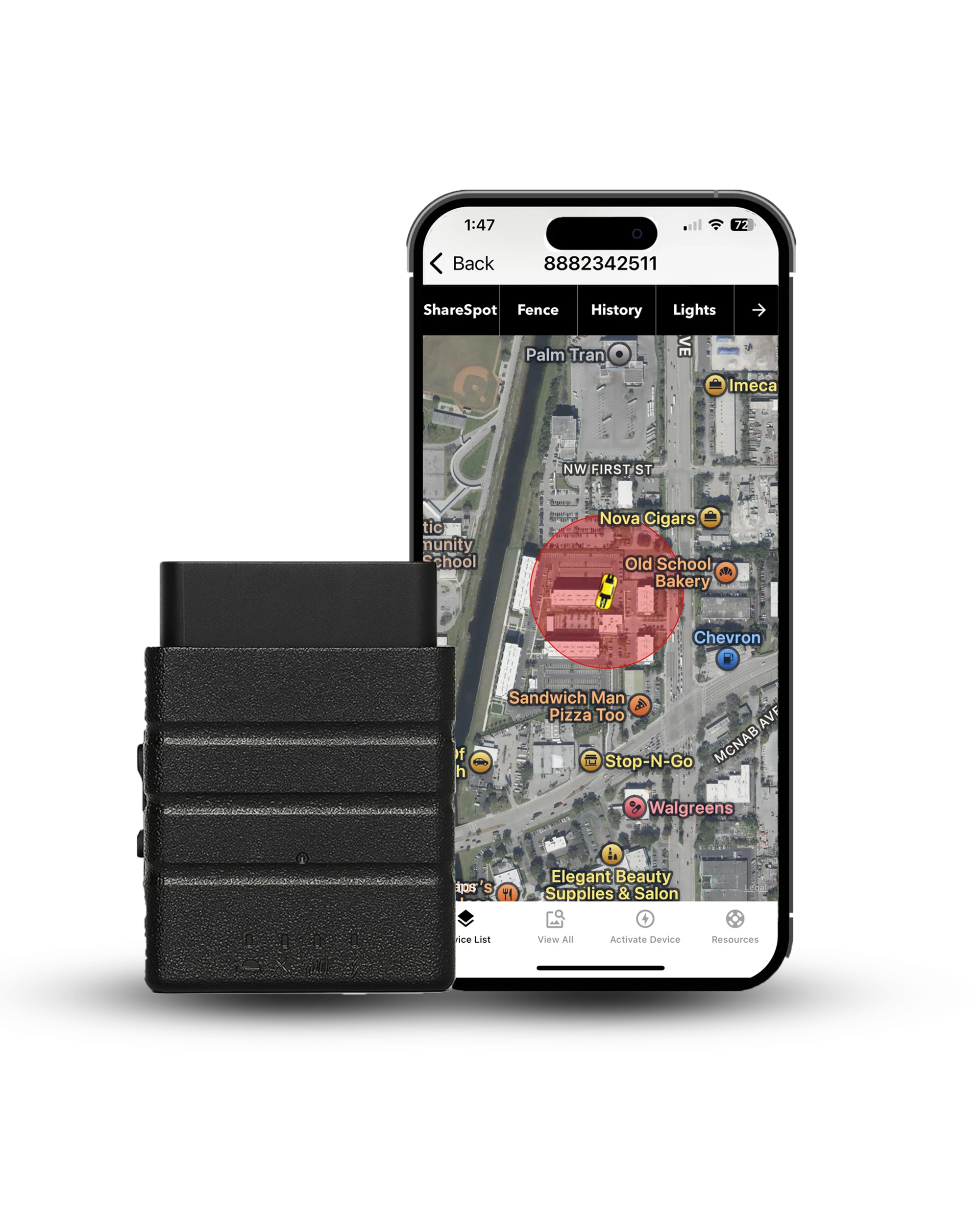
Konnect OBD2 GPS Tracker
World's fastest 3-second real-time car GPS tracker
- Updates every 3 seconds — 20x faster than most trackers
- Plug & Play — Simply plug into your OBD2 port, no tools needed
- Worldwide Tracking — 150+ countries with dependable real-time GPS updates
Triangulation vs. Trilateration: The Core Difference

This is where almost every GPS explanation on the internet gets it wrong, including articles published by major technology outlets.
| Feature | Triangulation | Trilateration |
|---|---|---|
| Uses Angles | Yes | No |
| Uses Distances | No | Yes |
| GPS Uses It | No | Yes |
| Surveying Uses It | Yes | Sometimes |
| Requires Line of Sight | Yes | No |
| Typical Accuracy | Lower | Higher |
| Works in 3D Space | Limited | Yes |
Triangulation is a technique that determines an unknown location by measuring angles from two or more known points. Surveyors used it for centuries with instruments called theodolites. They establish a known baseline between two fixed points, measure the angle from each end to a distant target, and calculate where those angled lines intersect. The key requirement is that angles must be measurable, which demands direct line-of-sight contact between points.
Trilateration determines an unknown location by measuring distances from three or more known points, with no angle measurement involved at any stage. GPS satellites do not measure angles to your device. Each satellite measures how long its radio signal takes to reach the receiver. That time gap is converted into a distance. Three distances define three overlapping spheres. Where those spheres intersect is your location.
The reason GPS uses trilateration instead of triangulation is straightforward. Measuring precise angles to satellites orbiting 12,550 miles away from a moving point on Earth's surface would be technically complex and far less accurate than measuring signal travel times. Distance measurement through timing is something GPS satellites can do with extraordinary precision using atomic clocks accurate to within a few nanoseconds.
How GPS Satellites Work

The GPS constellation operated by the U.S. Space Force consists of at least 24 operational satellites orbiting Earth at an altitude of approximately 12,550 miles. Each satellite completes two full orbits every 24 hours. From any point on Earth's surface, between 6 and 12 satellites are visible above the horizon at any given moment.
Every GPS satellite carries an atomic clock accurate to within a few nanoseconds and continuously broadcasts two things: its exact position in orbit and the precise time the signal was transmitted. Those two pieces of information are everything a receiver on the ground needs to calculate a distance.
A GPS receiver captures those broadcasts, compares the transmission timestamps to its own internal clock reading at the moment each signal arrives, converts each time difference into a distance using the speed of light, and runs the trilateration calculation across all visible satellites simultaneously.
The Trilateration Process: Step by Step
Step 1: One Satellite Produces a Sphere

A single GPS satellite tells the receiver one thing: you are a specific distance away from me. That distance could describe any point on a sphere with a radius equal to that distance, centered on the satellite. One satellite alone narrows your position to an entire sphere of possible locations, which covers millions of square miles.
Step 2: A Second Satellite Narrows It to a Circle

A second satellite produces its own sphere. Two spheres of different sizes and centers overlap along a circle where their surfaces intersect. Your location is now somewhere on that circle, which is far more specific than an entire sphere but still covers an enormous area.
Step 3: A Third Satellite Narrows It to Two Points

A third satellite produces a third sphere. That sphere intersects the circle from the first two satellites at exactly two points. Your location is one of those two points. One point typically sits deep in space, far above Earth's atmosphere. The other sits on or near Earth's surface. Since a GPS receiver is obviously not in outer space, the surface point is selected automatically, producing a two-dimensional latitude and longitude fix.
Step 4: A Fourth Satellite Adds Altitude and Removes Clock Error

This is the step most explanations skip, and it is the most important one for real-world accuracy.
Consumer GPS receivers do not use atomic clocks. Equipping every phone and tracking device with an atomic clock would cost thousands of dollars and weigh far too much. Instead, devices use inexpensive quartz clocks that drift over time. Even a timing error of one millisecond translates to a position error of approximately 300 kilometers, because signals travel at the speed of light.
A fourth satellite signal allows the receiver to solve for four unknowns simultaneously: latitude, longitude, altitude, and its own clock error. By finding the one clock correction value that makes all four distance measurements consistent with each other, the receiver eliminates its timing inaccuracy without needing an atomic clock. The fourth satellite also adds the third spatial dimension, converting a flat two-dimensional coordinate into a precise three-dimensional location, including altitude.
How GPS Calculates Distance Using the Speed of Light

GPS signals are radio waves that travel at the speed of light, covering approximately 186,000 miles every second. Each satellite embeds a precise timestamp into its signal at the moment of transmission. A GPS receiver records the exact moment each signal arrives and compares that arrival time to the embedded transmission timestamp. The difference is the signal travel time.
The distance formula is:
Distance = Speed of Signal x Travel Time
Since the signal speed is constant at the speed of light and the travel time is measured precisely, the distance calculation is straightforward. A signal traveling from a satellite 12,550 miles above Earth reaches the ground in approximately 67 milliseconds. Small variations in that travel time, measured in microseconds, translate into position differences of hundreds of meters, which is why atomic clocks on satellites and the fourth-satellite clock correction in receivers are both critical to accuracy.
GPS Accuracy: What Affects Your Position Fix

Standard GPS Accuracy
The basic GPS service provides approximately 7-meter accuracy 95 percent of the time anywhere on or near Earth's surface. Under ideal open-sky conditions with good satellite geometry, quality receivers consistently calculate position to within 3 to 5 meters. That level of precision is sufficient to identify which lane of a road a vehicle is traveling in.
Dilution of Precision
Accuracy depends not only on how many satellites are visible but on where those satellites are positioned across the sky. When satellites are clustered together overhead, the overlapping spheres produce a wide, imprecise intersection. When satellites are spread across a large area of sky, the spheres intersect sharply, and the position fix is tight. GPS engineers measure this geometric spread using a value called Dilution of Precision, or DOP. A lower DOP number always produces better position accuracy.
Atmospheric Delay
GPS signals slow slightly when passing through the ionosphere and troposphere on their way from orbit to the ground. This delay varies based on solar activity, time of day, weather conditions, and the angle of the satellite above the horizon. GPS receivers apply atmospheric correction models to account for most of this delay, though a small residual error typically remains.
Multipath Interference
In urban environments, GPS signals can reflect off buildings, bridges, and metal surfaces before reaching a receiver. A reflected signal travels a longer path than a direct signal, causing the receiver to calculate a slightly incorrect distance. This is the primary reason GPS accuracy drops in dense city centers. Devices like the Konnect OBD2 tracker handle signal gaps by storing location data locally and uploading the complete trip history automatically once clear coverage returns.
Enhanced GPS Systems
| GPS System | Typical Accuracy |
|---|---|
| Standard GPS (consumer) | 3 to 7 meters |
| WAAS-corrected GPS | 1 to 3 meters |
| Differential GPS (DGPS) | Under 1 meter |
| RTK GPS (survey grade) | 1 to 3 centimeters |
How Real-Time GPS Trackers Apply Trilateration
A GPS tracking device applies the same trilateration process described above and combines it with cellular connectivity to transmit location data to a mobile app or web platform in near real time. The GPS receiver calculates its position using signals from multiple satellites, while the cellular network sends those coordinates to the user, allowing vehicles, assets, or people to be monitored remotely.
The tracker plugs directly into the vehicle's OBD2 port and draws constant power from the car with no batteries required. The built-in GPS chip locks onto visible satellites and completes a full trilateration calculation every 3 seconds. Each position result is packaged with a timestamp and transmitted immediately over the cellular network to Konnect's servers, where the app displays the vehicle's location on a live map.
Because the Konnect tracker updates every 3 seconds rather than the 30 to 60 seconds common with most consumer devices, the vehicle appears to move continuously on the map rather than jumping between points that are half a mile apart. For monitoring a teen driver, tracking a fleet vehicle across a city, or confirming an employee's arrival at a job site, that difference in update frequency changes what the data can actually tell you.
The speed alert system runs off the same trilateration output. Each new position is compared to the previous one. Distance covered divided by elapsed time produces a speed reading. When that reading exceeds the limit you set, an alert goes to your phone immediately.
GPS Trilateration vs. Cell Tower Location: A Direct Comparison
| Feature | GPS Trilateration | Cell Tower Estimation |
|---|---|---|
| Method | Distance from satellites | Signal strength from towers |
| Typical Accuracy | 3 to 7 meters | 100 to 300 meters |
| Works Indoors | No | Partial |
| Works in Rural Areas | Yes | Limited |
| Requires Data Plan | No (reception only) | Yes |
| Used by Konnect GPS | Yes | For data transmission only |
Cell tower location estimation measures signal strength from multiple cellular towers and identifies the area where those signals overlap. Because towers are spaced miles apart and signal strength varies based on terrain, buildings, and obstacles, this method typically produces accuracy of 100 to 300 meters at best in urban environments and far less reliably in rural areas.
GPS trilateration using satellites produces an accuracy of 3 to 7 meters under normal conditions. Konnect uses satellite trilateration for position calculation and the cellular network only for transmitting that position data to the app. The location itself is always satellite-derived.
What Is Assisted GPS and Why Is It Important

Standard GPS receivers can take 30 seconds to several minutes to achieve a first position fix after being powered on in a new location. This cold start delay occurs because the receiver must listen to satellite broadcasts to download current orbital data before trilateration can begin.
Assisted GPS, or A-GPS, solves this by downloading current satellite position data from the cellular network instead of waiting to receive it from satellites directly. With this assistance, a receiver achieves a position lock in under 5 seconds. Most modern GPS tracking devices, including Konnect, use A-GPS for faster initial lock-on and more consistent positioning when satellite signals are briefly interrupted during a trip.
Other Satellite Navigation Systems That Use Trilateration
GPS is not the only satellite navigation system in operation. All major global navigation satellite systems use the same trilateration principle because measuring signal travel times is far more practical than measuring angles to satellites at orbital altitude.
| System | Country | Satellites | Coverage |
|---|---|---|---|
| GPS | United States | 31+ | Global |
| GLONASS | Russia | 24+ | Global |
| Galileo | European Union | 30 | Global |
| BeiDou | China | 35+ | Global |
| NavIC | India | 7 | Regional |
Modern smartphones typically receive signals from multiple systems simultaneously, which increases the number of available satellites, improves position accuracy, and speeds up initial lock-on time.
How to Diagnose a GPS Accuracy Problem
If a GPS tracker or navigation device produces inaccurate positions, the cause almost always falls into one of these categories:

The receiver cannot see enough satellites above the horizon. This happens in urban canyons, near large buildings, or when the device is inside a vehicle with significant metal shielding. Moving to an open area or repositioning the device improves satellite count.
All visible satellites are clustered in one area of sky, producing high DOP and a wide position intersection. Nothing can be done to change satellite positions, but waiting a few minutes changes the geometry as satellites move.
Signals are bouncing off nearby structures before reaching the receiver, causing incorrect distance calculations. Moving away from reflective surfaces improves accuracy.
The internal quartz clock has drifted significantly. Reacquiring a fourth satellite signal corrects this automatically.
Unusual ionospheric activity from solar events introduces small delays. Most receivers compensate automatically.
Satellite trilateration, every 3 seconds, on a live map
Konnect OBD2 plugs in once and completes a full trilateration calculation every 3 seconds — so your vehicle moves continuously on the map instead of jumping between points — with reliable coverage across 150+ countries and a free first year of service.
Sources
- U.S. Space Force. GPS.gov Official Site and Trilateration Explanation. gps.gov
- NASA Jet Propulsion Laboratory. Tracking Spacecraft With Trilateration. jpl.nasa.gov
- GIS Geography. How GPS Receivers Work: Trilateration vs. Triangulation. gisgeography.com
- Advanced Navigation. GNSS and Satellite Navigation Explained. advancednavigation.com
- Disaster.Shiksha. The Working Principle of GNSS: Trilateration Explained. disaster.shiksha
- Let's Talk Science. The Math Behind GPS. letstalkscience.ca
- OXTS. Trilateration vs. Triangulation: How Does Trilateration Work? oxts.com
- National Coordination Office for Space-Based Positioning, Navigation, and Timing. GPS Accuracy. gps.gov
About the Author

 Buy on Amazon